
North Sea helicopters first to be tracked by offshore multilateration
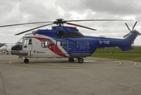
Surveillance of oil support helicopter operations using multilateration instead of radar has been launched over the North Sea. Multilateration is not...
Keep reading this article by becoming a FlightGlobal member now
PLEASE REGISTER FOR FREE OR SIGN IN TO CONTINUE READING

You have reached your limit of free articles for this period. Register for a FREE account to read this article and benefit from:
- Increased access to online news and in-depth articles from:
- FlightGlobal Premium covering the global aviation industry
- Airline Business providing insight for business leaders
- Weekly newsletters on topics across the industry
From making its debut as a magazine in 1985 through to its evolution into an online data and analysis tool, Airline Business has forged a reputation for providing high-quality, in-depth coverage of the airline sector’s strategic and economic drivers. Our trusted insight gives users a competitive edge in the global industry.