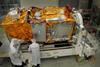
With the imminent shipping of its Sentinel-2A satellite from Germany to its launch site in Kourou, French Guiana, the European Space Agency is readying the next step in an ambitious plan to orbit a highly sophisticated constellation of Earth observation satellites for mapping and to monitor features ranging from vegetation to natural disasters.

The July launch of Sentinel-2A will provide advanced optical observation capabilities to complement the Sentinel-1A radar satellite launched last year. Identical “B” versions of both satellites are scheduled for launch in 2016; the pairs will orbit the poles 180° apart, to provide high resolution imagery of any point on the globe with a rapid, five-day repeat cycle.

And, the European Commission has confirmed that Sentinel-1 and -2 will be the first, “anchor” users of the proposed high-speed European Data Relay System, an agreement that opens the way for satellites prime contractor Airbus Defence & Space to invest in the completion of EDRS and develop a third-party market for its services. EDRS will use transponders on geosynchronous satellites to receive data by laser from the Sentinels, and eventually other spacecraft, and beam it straight down to fixed-position ground stations.

The result will be near real-time data acquisition; today, the wait for an orbiting satellite to come in view of a ground station to download data can be as long as the 100mins taken to orbit at about 750km.

EDRS is expected to be a significant factor in the success of Sentinel-2, which will generate vast quantities of data – all of which will be freely available for use by scientists and commercial entities. Working in 13 spectra with resolution as fine as 10m and harvesting a 250km-wide swath of imagery, the Sentinel-2 satellite represents a significant step forward in capability compared with their predecessors, the current generation of French SPOT and US Landsat craft. ESA’s director of Earth observation Francois Spoto describes Sentinel-2’s wide-swath and fast repeat imaging as able to provide an unprecedented degree of “carpet mapping” of land and coastal regions.

Showing the satellite to a group of journalists at IABG’s clean room facilities in Ottobrunn, near Munich, where the final testing was completed before Sentinel-2A is shipped to Kourou by an Antonov transport aircraft, Spoto added that the mission is also important in providing scientists with data continuity from the SPOT and Landsat missions, the latter currently being the eighth iteration of a series first launched in 1972, with plans underway for Landsat 9.

The Sentinel missions form the space-based elements in the EU’s Copernicus programme, which also relies on land-based sensors and other data gathering to provide a comprehensive picture over time of the evolution of Earth’s biodiversity, water, soil, forests and other resources. Ultimately, six Sentinel satellite series are planned, with the Sentinel-6 – to provide high-precision measurements of ocean topography – expected to be launched in 2020.

Sentinel-2A in IABG clean room

Final preparations before shipping to Kourou; Sentinel-2A in the IABG cleanroom, Ottobrun

Airbus Defence & Space

Source: Flight International

Topics