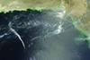
According to NASA's Earth Observatory information service, atmospheric gravity waves "form when buoyancy pushes air up, and gravity pulls it back down". But while simple enough to define, the phenomenon is anything but easy to monitor.

This photograph of the Arabian Sea, taken by the Moderate Resolution Imaging Spectroradiometer (MODIS) on NASA's Terra satellite in 2005, was a lucky strike aided by sun glint; when a satellite views the surface of the at the same angle as sunlight reflects off it, smooth ocean water appears mirror-like and rougher surface waters appear dark. Sometimes, adds NASA, "the sun glint region of satellite images reveals interesting ocean or atmospheric features that the sensor doesn't usually observe".

In this case, waves clearly visible on the surface are not ocean waves but, rather, the "impression" on the water of atmospheric gravity waves touching the surface on their way down, at their troughs. Note the pattern of small clouds; these often form at the crest of atmospheric gravity waves and are visible in this image.

 gravity waves

NASA

To complicate interpretation of the image, though, smaller waves visible on the surface are probably just ordinary ocean waves.

Given the complexity of the problem, Todd Lane's call from the University of Melbourne and Australia's Centre of Excellence for Climate System Science for better modelling of the high atmosphere is fortunately not a lonely cry in the dark (see related story). MODIS is just one of many sophisticated weather observation satellites being deployed to better understand the forces at work in Earth's atmosphere.

In June, the European Space agency launched the third in Europe's latest-generation series of four MSG (Meteosat Second Generation) geostationary satellites for Europe's EUMETSAT weather service, and MSG-3 returned its first picture of the Earth earlier this month en route to operational service after a six-month commissioning period. MSG-3, with its bird's-eye view of Europe and Africa, carries as its principle payload the Spinning Enhanced Visible and Infrared Imager (SEVIRI), designed to improve very short-range forecasts - in particular for rapidly developing thunder storms or fog.

SEVIRI scans Earth's surface and atmosphere every 15min in 12 different wavelengths, to track cloud development, and can pick out features as small as 1km (0.54nm) across in the visible bands, and 3km in the infrared range.

Secondary payloads include a radiation sensor to measure the amount of solar energy that is reflected back into space and the amount of infrared energy radiated by the Earth itself, to better understand climate processes. There is also a search and rescue transponder on board to turn MSG-3 into a relay for distress signals from emergency beacons.

MSG-4, the last in the series, will launch in 2015.

Source: Flight International