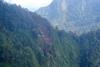
Indonesian air traffic control was unaware that the crashed Sukhoi Superjet 100 was an airliner because it had been coded as a Sukhoi Su-30 fighter.

Flight-data personnel at Jakarta, having received a flight plan for the Superjet's demonstration, coded the aircraft as an Su-30 because the database being used did not include the twinjet.

Investigators probing the fatal Superjet crash on 9 May indicate that this misleading entry influenced a crucial decision to permit the airliner to descend to low altitude in a mountainous region, shortly before it struck terrain.

The inquiry also reveals that the aircraft was inadvertently set on its fatal collision course by the pilots who, distracted, failed to keep the aircraft turning during an orbit.

When Jakarta approach accepted responsibility for the Superjet during its flight, the controller checked the aircraft type through his radar display.

Owing to the coding, the data indicated that the aircraft was an Su-30. The controller believed the aircraft was a military fighter flying to the Bogor region for a test flight. Bogor is the location of the Atang Sanjaya military training area.

As the aircraft headed south from Jakarta the Superjet pilot requested a descent to 6,000ft and an orbit.

Indonesia's National Transportation Safety Committee says this request was based on the pilot's preparation for a runway 06 approach when the aircraft returned to Jakarta Halim airport. This approach differed from an earlier demonstration flight that day, which had used the opposite-direction runway 24.

Cockpit-voice recordings show that the captain explained to another individual on board that the descent and orbit were intended to bleed altitude in order to avoid being too high for the 06 approach.

The NTSC says the Jakarta approach controller was "not concerned" about the boundaries of the training area, which had an upper airspace limit of 6,000ft.

"The [controller] assumed that a military aircraft was eligible to fly in this area," it adds. "As a result [he] approved the aircraft to descend to 6,000ft."

While the earlier demonstration flight had turned left, northeast of Mount Salak, and headed back to Jakarta, the second flight instead performed a right-hand orbit which took its flightpath directly north of the peak.

Ironically, as the aircraft turned, the captain demonstrated the terrain-awareness function to a customer representative in the cockpit. Because the aircraft, at this point, was pointing northeast the terrain ahead was relatively flat, and the captain said there was "no problem with terrain at this moment".

To perform the orbit the pilot sequentially adjusted the heading selector - setting it to 333°, then 033°, 103°, 150° and 174°. Investigators believe the crew became distracted by discussions about fuel consumption with the customer representative, and did not notice when the Superjet dutifully rolled out onto its selected heading, 174°, which took it south towards Mount Salak.

By the time the pilots adjusted the heading selector again, to 325°, nearly a minute had gone by since the aircraft exited its orbit. The new heading turned the aircraft into the mountain peak, generating terrain-avoidance warnings which the pilots disregarded as being false.

None of the 45 occupants survived the impact. The NTSC says Jakarta approach had been busy handling several other flights and did not notice that radar contact had been lost with the Superjet for more than 20min. Only after the controller contacted Halim tower, the NTSC adds, did he realised the missing aircraft was a civil airliner.

Source: Air Transport Intelligence news