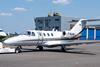
French investigators have disclosed that a Cessna Citation CJ1 started descending in cruise while its pilots believed they were flying level, before reaching such a low height on approach that the crew had to take evasive action.

The aircraft, operated by Valljet, had departed Limoges for Paris Le Bourget on 14 March.

As the CJ1 climbed, the pilots detected an inconsistency between the altitude readings on their primary displays, but opted to address the problem once established in cruise.

The jet levelled at 18,000ft – according to the captain’s display – and the crew informed air traffic control of an altimetry issue, asking the controller to confirm the flight’s altitude.

Although the controller replied that the displayed altitude was 18,000ft, this information was not independent, but derived from the aircraft’s transponder.

Preliminary findings from French investigation authority BEA state that the aircraft’s GNSS altitude at this point was 15,650ft.

F-HJAV-c-AirTeamImages

Source: AirTeamImages

Pilots of the jet (F-HJAV) executed a terrain-avoidance manoeuvre 700ft above ground

After carrying out diagnostic procedures in cruise, the crew believed the first officer’s altimeter was incorrect, and selected the captain’s air-data computer as the source for both pilots’ displays.

The aircraft was transferred to the Nord en route centre, the crew declared they were flying at 18,000ft but did not mention the earlier altimeter problem.

But over the course of nearly 20min, despite the altimeter’s reading 18,000ft, the actual altitude gradually declined from 15,300ft to 12,600ft.

As the flight neared Paris, the crew was instructed to descend. The flight was cleared to 9,000ft when its pilot displays showed 13,000ft – but the jet was already at a GNSS altitude of 8,000ft.

With difficulties in contacting Paris approach control adding to the crew’s workload, the aircraft reached 3,000ft – and was continuing to descend at 270ft/min – while the crew still believed they were commencing a level approach to Le Bourget at 9,000ft.

The crew told the inquiry that they received a terrain warning and ‘pull up’ alert, and the captain initiated a climb manoeuvre in reponse.

Flight-data analysis shows the aircraft was only 700ft above ground, despite the altimeter’s still reading 9,000ft.

The jet climbed by around 1,000ft and the crew asked air traffic control for their indicated altitude, to which the controller replied that his reading was 9,600ft.

When the crew informed that they appeared visually to be flying lower, the controller added that they should not rely on the air traffic control display because the information was obtained from the transponder.

F-HJAV flightpath-c-BEA

Source: BEA

Data for the last 30min of flight shows the displayed altitude (blue) against the GNSS altitude (red)

Air traffic control subsequently assisted the crew with guidance to the localiser and glidepath, and the pilots were able to make visual contact with the ground and land safely. Even after the jet touched down, the air traffic control display still showed it at 13,000ft.

Neither of the pilots, nor the two passengers, were injured and the jet (F-HJAV) was undamaged.

BEA is still assessing the incident and has yet to reach final conclusions.

But it points out that, during the final 20min of flight, the jet flew “at high speed” near other traffic, operating under visual flight rules. Given the incorrect altitude from the transponder, the collision-avoidance systems of other aircraft, as well as altitude and conflict alerts of air traffic control, were rendered “ineffective”.

BEA adds that, although the pilots had detected a discrepancy between the three altimeters during the initial climb, they were “not aware” of a procedure to compare barometric altitudes with those of the aircraft’s GNSS equipment.