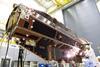
The European Space Agency is making a risky manoeuvre with one of its most sophisticated satellites, but by lowering GOCE's orbit deeper into the high-drag outer reaches of the atmosphere scientists hope to dramatically improve their already superlative measurement of the Earth's gravity field.

GOCE - or Gravity field and steady-state Ocean Circulation Explorer - has already had its mission extended by a year to the end of 2012, more than tripling the amount of data recorded during its original mission plan since launch in March 2009. But now mission controllers at ESA's ground centre in Darmstadt, Germany, are lowering GOCE's orbit in a bid to make a "second major leap" in data quality before the spacecraft runs out of fuel next autumn.

In August, GOCE's orbit was reduced by 10km (6.2 miles) to just 247km above the Earth. In November, the orbit will be reduced by a further 11km, roughly doubling GOCE's atmospheric drag. The spacecraft is actually streamlined to travel as smoothly as possible during its extremely low orbit - about 160km lower than the International Space Station, which itself needs periodic boosting to reverse the slowing effect of remnant atmosphere.

ESA GOCE orbiter

 European Space Agency

Flying smooth and low is the key to measuring minute variations in the Earth's gravitational pull. Mission manager Rune Floberghagen says that while the purpose of GOCE is to measure the geoid as accurately as possible by repeating measurements, the error reduction achieved by gathering further data at the same 260km orbit would be increasingly small.

However, he says, by flying lower, GOCE should provide a big increase in accuracy, down to 50-80km - though at the cost of a dramatic risk to the spacecraft. At its original design orbit, GOCE's controllers could tolerate an eight-day outage of the ion propulsion system, which allows for very precise speed control, before using fuel to increase altitude. Now, their operating rule will be to allow no more than two days of ion system outage. And, controllers must be extremely diligent, as atmospheric drag rises and falls with solar activity, which is in a high and volatile cycle.

Understanding local gravity helps explain the subsurface structure of the Earth, which is not a perfect Newtonian sphere with uniform gravity; variations in density create what is shown in a gravity map, or geoid as a lumpy sphere. This lumpy shape represents the Earth's gravitational equipotential surface, with low-gravity areas shown as high points. GOCE is building on measurements from earlier craft including the tandem-spacecraft NASA-German Aerospace Center Gravity Recovery and Climate Experiment, which flew a decade ago.

The geoid helps explain sub-surface structures and monitor ground water, and enhances radar altimeter measurements of sea level and ice thickness as taken by satellites including ESA's CryoSat. As GOCE's name implies, it is also an important tool in analysing ocean currents.

By flying so low, GOCE is also providing much data on air density and wind conditions at the edge of Earth's atmosphere. Floberghagen reckons the data should be useful to colleagues designing re-entry craft, but admits he has yet to be contacted for assistance.

Source: Flight International

Topics