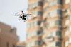
Following the destruction caused by a major earthquake in Nepal earlier this year, a humanitarian unmanned air vehicle (UAV) coordinator is calling on more operators to take their systems to the country, in order to provide aerial services to aid in analysis of the event.

After the earthquake in April 2015, 15 UAV teams were deployed to Nepal to collect surveillance data and to carry out mapping work, but more still needs to be done in order to assess the true degree of the effects caused by the disaster.

A team from the Qatar Computing Research Institute’s UAViators Humanitarian UAV Network has carried out work using rotary-wing UAVs such as the DJI Phantom. This included performing 60 flights in Kathmandu in September, authorised by the Civil Aviation Authority of Nepal.

In six months’ time, the team is planning to also test some fixed-wing systems in Nepal. Patrick Meier, director of social innovation at the institute and founder of UAViators, is calling on more teams with a desire to help to join them.

“Please come to Nepal and help us; help generate the first generation of UAV pilots in Nepal,” Meier told the Commercial UAV Show in London on 20 October.

“We’ve been forming and championing the safe use of UAVs for these humanitarian efforts,” he continued, adding that UAViators has been working alongside numerous organisations to develop a code of conduct for the use of UAVs in humanitarian operations. This focuses on the safety and legality of their use, and stresses the importance of only using them when they are the most viable method for carrying out the work.

Phantom UAV - Rex

Rex Shutterstock

Similar to the operations in Nepal, Cyclone Pam which hit Vanuatu last March led to a series of UAV teams being deployed to monitor and map the area, including from Heliwest and X-Craft. In that case, it was demonstrated that UAVs can be easily integrated into manned aircraft operations at airfields, as they were operated alongside Royal Australian Air Force Lockheed Martin C-130Js transports that were making cargo deliveries to the area.

“We were able to operate alongside the airfield because we worked with the government,” Meier noted. “You just need a willing and forward-thinking government and air traffic control that will co-operate.”

The University of Southampton is now using data that has been collected by UAVs in Vanuatu to develop algorithms that will allow the mapping of natural disaster areas in real time.

Source: FlightGlobal.com