


More than two and a half years after Malaysia Airlines flight MH370 went missing, none of the search organisations trying to locate the main area of the Boeing 777-200’s wreckage is voicing confidence. So where does the multinational search effort for the aircraft – and the 239 people lost with it – stand today?
Many floating parts of the aircraft’s composite structure have washed up on beaches at the far west fringes of the Indian Ocean – more were positively identified at the beginning of October – but this has not, so far, made any difference to the overall search plans.
The first discovered parts were not found until well over a year after the flight was reported missing on 8 March 2014, and their continued discovery merely confirms that this vast ocean is the widebody’s final resting place.
Prof Eric Jansen, from the Italy-based Euro-Mediterranean Centre for Climate Change, is using computer modelling of regional winds and currents to back-track the probable drift paths of beached aircraft components to estimate their point of origin. With each new piece of debris found, the model is run again to see if it homes in on an area. But at present the technique does not disprove existing theories, nor indicate new ones with sufficient certainty to make them usable.
Meanwhile, the meticulous seabed search in the oceanic area calculated to be where the aircraft came down is expected to be completed by December, hampered at present by the southern hemisphere’s late winter weather.
The de facto search co-ordinator is the Australian Transport Safety Bureau (ATSB), which says that unless “new information” becomes available, the search will not extend outside the area indicated by its exhaustive mathematical calculations, which are based on communications satellite “handshake” signal responses from the aircraft.
On 21 September, the ATSB said that following a July meeting between ministers from Australia, China and Malaysia it was agreed that unless the aircraft was located within the current 46,300 mile² (120,000km²) search area “and in the absence of credible new evidence leading to the identification of a specific location of the aircraft” the search would be suspended. That, according to ATSB estimates, will be December, which is mid-summer in the southern hemisphere: a season when search operations become easier.
All the calculations made and agreed by the multinational search team – and by those very few credible individuals or independent groups who have published estimated positions for the lost aircraft’s resting place – contain some assumptions. They all, however, work from the last location at which the aircraft was recorded on primary radar, and the nearby point at which they all deem it to have turned south. They all come to similar – but not identical – conclusions about where to look for the aircraft, and these are about 1,080nm (2,000km) off the coast of Western Australia.
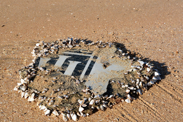
Debris was washed ashore on beaches in the western Indian Ocean
ATSB
Most of the countless other hypotheses that have been aired are based either on conspiracy theories or misunderstandings about navigation and aviation in general, and about the 777 in particular. These have included abduction to an unknown place, an onboard fire or a sudden decompression.
The aircraft malfunction scenarios all ignore the fact that the crew had the means to communicate distress but did not do so. Such theories also have no explanation for the surreal way in which, during the air traffic control handover from Kuala Lumpur to Ho Chi Minh control, the captain bid goodnight to the former but never called the latter. Almost simultaneously, the aircraft’s transponder was turned off and the 777 carried out a left turn from its north-easterly heading towards the west, and was tracked by military radar for nearly 2h before going out of range over the northern Malacca Strait. The ultimate turn south was derived from analysis of a mobile telephone call signal to a passenger on the aircraft, backed up by the fact that it was not subsequently picked up on defence radars to the north, east or west.
On that basis, the scenario still considered most likely is that someone on board intended the aircraft to fly the course it did, and was in control of it, either throughout the flight or at least until it was set up on its final southerly heading into the southern part of the Indian Ocean, flying on autopilot.
Peter Foley, in charge of the ATSB’s search team, has been quoted by Associated Press as saying that, among the beached wreckage, damage to a recovered flaperon indicates that it was retracted when the 777 hit the sea, implying that there was no attempt at a controlled ditching. Others, however, have reached the reverse conclusion. But there is no direct evidence of any of this; only a lack of evidence for an alternative.
Press speculation that it was the aircraft’s captain who carried out this extraordinary exercise are similarly not backed up by evidence. He had no recorded history of instability or of recent behavioural changes. Therefore, if the theory that this was a controlled exercise is to make sense, it leaves only hijack by someone whom the crew trusted. But whoever it was must have had a sophisticated knowledge of the 777 and its systems.
Theorising as to how a pilot could have hijacked the aircraft without resistance from others on board involves pure speculation, but the initial turn away from the aircraft’s scheduled course for Beijing was carried out late at night when most passengers would have been sleeping or trying to sleep, so lack of awareness would have been the first means. Keeping them unconscious could be achieved by depressurising the aircraft at cruising altitude while the controlling pilot donned an oxygen mask. But only finding the aircraft will give investigators the chance to find out the truth.
So far, the ATSB-led search has used the knowledge of the aircraft’s early radar-tracked route plus sophisticated mathematical interpretations of what the vestigial satellite handshake signals reveal about where it could be. The Australian, Malaysian and Chinese search team have been aided in this work by Inmarsat, the operator of the communication satellite that sent and received the signals and clearly an expert agency in this field.
Unfortunately, the handshake signals do not provide an actual position, but a circle on the surface of the globe, with the satellite position at its centre, described by the range of the aircraft from the communications satellite at each “ping”.
From the aircraft’s final radar position, the search team knew the aircraft could not have flown to most of the circle because that was beyond its range, so they were able to narrow the search down to an arc representing the reachable section of the circle at the time of the seventh and final handshake signal, which also happened to take place at the time the 777 would have run out of fuel.
But although the ATSB has talked to the generators of a couple of the more credible alternative MH370 position calculations, it has not – so far at least – shown any inclination to take them into account. Yet suspending the search without also checking plausible alternative calculated positions that are so close would be unthinkable.
The world may never know what happened to flight MH370, but it certainly wants to.
NEED FOR A WIDER SEARCH?
One of the most credible alternative systems for calculating where the aircraft’s main wreckage is likely to be found was put forward by an independent individual who also happens to be an accomplished mathematician and an active 777 captain.
Simon Hardy’s calculations are based on geometry and time/distance ratios between the satellite handshake signal arcs, which makes the methodology for his workings different from those of the ATSB-led group and which also point not just to an arc, but to a proposed location close to the seventh and final arc.
The only assumption Hardy makes is that, once the aircraft had turned on to a southbound course, the autopilot/flight director was set to hold a steady airspeed and track. He determined the speed and the true track (rather than magnetic) by measurements of the time and distance between handshake signals, and although not all his assumptions were identical to those of the ATSB, he used the same start point and also the team’s main assumption – that the satellite-described range arcs are true indicators of the aircraft’s position in time.
Hardy’s geometrically derived result shows MH370’s calculated track to be 188° (true), and the derived speed to be 488kt (903km/h) (true air speed), which happens to be close to cruise speed for the aircraft. His methodology and calculations were published by FlightGlobal in December 2014, although he has marginally modified the predicted final resting place since then.
Hardy puts the resting position of MH370 just outside the southern end of the seventh-arc-defined search zone, which is where the final part of the planned search is taking place. But unless the ATSB modifies its plan, Hardy’s predicted location will not be examined.
Although the ATSB has known of Hardy’s calculation for some time – and has not criticised it – it can be argued that it is classifiable as “new information” under its criteria for continuing the search or at least extending it slightly.
Hardy says that if the ATSB does not locate the wreckage of flight MH370 within its planned search area and refuses to explore the zone he has identified, he will consider a crowdfunding effort to finance a few weeks of additional search activity.
Source: FlightGlobal.com